
Georgia, Inland Waterways, National Category
Startup Uses Drone for Cleaning Water, Collecting Data

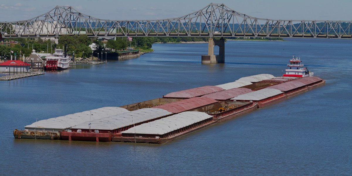

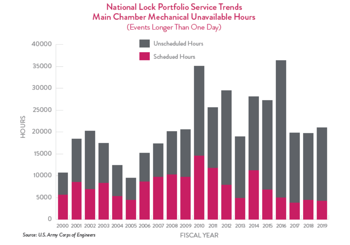
The Mississippi River and its tributaries, as well as the Columbia, Sacramento, and San Joaquin Rivers on the West Coast make up nearly 12,000 miles of navigable waterways — the U.S. freight network’s “water highway.” Inland waterway infrastructure includes locks and dams as well as navigation channels. Investing in this infrastructure helps move agricultural exports and relieves strain on other transportation modes. One barge can move as many tons as 70 tractor-trailers. Recent boosts in federal investment and an increase in user fees have begun to reverse decades of declining lock and dam conditions, with unscheduled lock closures reaching a 20-year low in 2017. While this is encouraging, the system still reports a $6.8 billion backlog in construction projects and ongoing lock closures — totaling 5,000 hours between 2015 and 2019 — harming the industries that rely on the waterways to get their goods to market. The U.S. Department of Agriculture estimates delays cost up to $739 per hour for an average tow, or $44 million per year.
Download Report
can move as many as
70 tractor trailers or 16 train cars.
for an average tow,
or $44 million per year.
move nearly
830 million tons of cargo annually.
The waterway network is comprised of approximately 12,000 miles of inland navigation channels as well as an additional 11,000 of intracoastal waterways owned and operated by the U.S. Army Corps of Engineers (USACE). Most of the mileage of USACE’s inland network is comprised of the Mississippi River and connecting waterways. Additional navigable waterways include the Columbia River that makes up the border between Washington and Oregon and the Sacramento and San Joaquin Rivers in California.
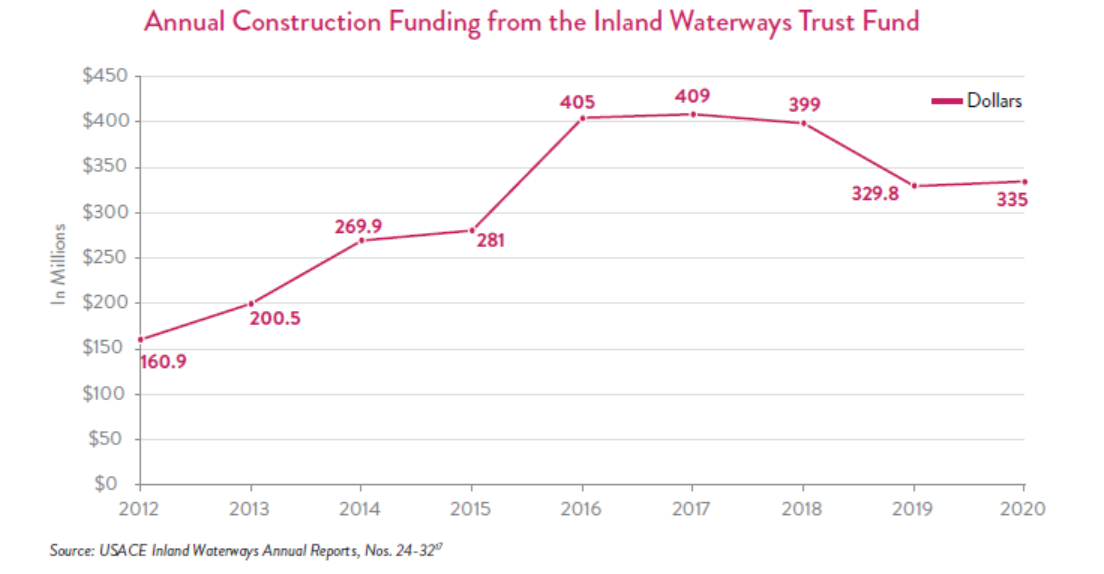
Traditionally, 50% of a major rehabilitation or new construction project is paid for with support from the U.S. General Fund, and 50% is supported with revenue from the Inland Waterways Trust Fund (IWTF) account.
The IWTF collects money from a 29-cents-per-gallon tax on barge fuel paid by shippers using the navigation channels. In 2015, a much sought-after increase to the barge fuel tax was signed into law, which now raises approximately $25 million in additional annual funds and has helped cut down on the backlog of maintenance projects.
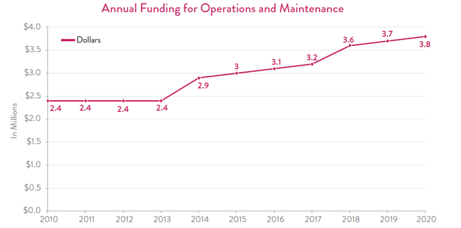
Regular operations and maintenance needs, such as minor lock repairs and dredging, are paid for with appropriations from the General Fund. Project costs are authorized through the Water Resources Reform and Development Act (WRDA) and appropriated by the Energy and Water Appropriations Act. In recent years, Congress has not only regularly passed WRDA legislation, but inland waterways have been the beneficiary of robust appropriations, which have spurred investment along the system and increased reliability for its users.
The inland waterway network is very safe to operate. According to USDA, on a million-ton-mile basis, there are 21.9 rail fatalities and 79.3 truck fatalities for every one fatality on the waterways system.
Geographic Information System (GIS)
Federal funding for new and existing federal navigation projects; designations of high- , medium- , and low-use waterways; and private investment decisions all hinge on tonnage reporting. Traditionally, shippers reported tonnage based on national inland port boundaries rather than geopolitical boundaries. For example, the municipality of Helena, Arkansas, denotes their port by one set of boundaries, while legislation designates different boundaries, and shippers have operated under a third geographic area. This contributes to incorrect tonnage reporting as goods move through these inland ports. To obtain more accurate tonnage reporting, USACE is creating a Geographic Information System (GIS) to prepare enterprise-wide statistical port boundaries. Utilization of geospatial data will improve public reporting and, in turn, create a more accurate data map for policymakers to use when making funding decisions.

Solutions that Work
Give USACE the authority to manage a project from start to finish and ensure sufficient and timely appropriations from Congress to avoid costly stop-and-start of construction that has traditionally taken place.
Fund waterways projects at the authorized levels and do so consistently, passing a Water Resources Development Act on a two-year cycle.
Develop and implement a standardized measurement for delays on the system.
Ensure that full use of the Inland Waterways Trust Fund continues to be appropriated.
Increase the amount spent on operations and maintenance of the inland waterways each year by providing more robust appropriations and consider a prioritization method that can more strategically direct limited funds to needy projects.
To excavate or deepen the bed of a harbor, river, or other area of water by scooping out sediment and moving it to a different location. This technique is often used to keep waterways navigable.
An enclosure consisting of a section of canal that can be closed to control the water level. It is used to raise or lower vessels that pass through it.
Barges can be lashed together to form a “tow.” A tow may consist of anything from four to six barges on smaller waterways to over 40 barges lashed together on deeper and larger portions of the waterway system.25
1 U.S. Department of Agriculture, “Importance of Inland Waterways to U.S. Agriculture,” August 2019.
2 Belk, Edward E., Jr., PE, “U.S. Army Corps of Engineers Civil Works Program Update,” [PowerPoint Presentation]. Waterways Council, Inc., February 13, 2019.
3 U.S. Army Corps of Engineers, Handout from Deb Calhoun.
4 U.S. Department of Agriculture, “Importance of Inland Waterways to U.S. Agriculture,” August 2019.
5 U.S. Army Corps of Engineers, Institute of Water Resources, “Inland Waterway Navigation: Value to the Nation,” May 2000.
6 U.S. Army Corps of Engineers, “The U.S. Waterway System 2018 Transportation Facts & Information,” November 2019.
7 Congressional Research Service, “Inland Waterways Trust Fund,” February 26, 2018.
8 U.S. Army Corps of Engineers, “Value to the Nation Fast Facts,” 2017.
9 Waterways Council, Inc., “An Inland Marine Highway for Freight,” Accessed December 12, 2020.
10 U.S. Department of Agriculture, “Importance of Inland Waterways to U.S. Agriculture,” August 2019.
11 U.S. Army Corps of Engineers, “Value to the Nation: Navigation.” Accessed December 12, 2020.
12 U.S. Army Corps of Engineers, Institute for Water Resources, “The Declining Reliability of the U.S. Inland Waterways System.”
13 The U.S. Waterways Foundation and the Maritime Administration, “The Impacts of Unscheduled Lock Outages,” October 2017.
14 Mid America Freight Coalition, “Modal Investment Comparison: The Impact of Upper Mississippi River Lock and Dam Shutdowns on State Highway Infrastructure,” October 2017.
15 Belk, Edward E., Jr. PE, “U.S. Army Corps of Engineers Civil Works Program Update,” [PowerPoint Presentation]. Waterways Council, Inc., February 13, 2019.
16 Congressional Research Service, “Inland and Intracoastal Waterways: Primer and Issues for Congress,” July 2020.
17 U.S. Department of Agriculture, “Inland Waterways Users Board 32nd Annual Report,” August 2019.
18 U.S. Army Corps of Engineers, Louisville District Website, “Olmsted Locks and Dam.”
19 U.S. Department of Agriculture, “Importance of Inland Waterways to U.S. Agriculture,” August 2019.
20 GAO, “Inland Waterways: Action Needed to Increase Budget Transparency and Contracting Efficiency,” November 2018.
21 U.S. Department of Agriculture, “Importance of Inland Waterways to U.S. Agriculture,” August 2019.
22 U.S. Department of Transportation, Bureau of Transportation Statistics, “Port Performance Freight Statistics in 2018, Annual Report to Congress 2019,” 2020.
23 U.S. Army Corps of Engineers San Francisco District and Port of West Sacramento, “Draft SEIS/SEIR, Sacramento River Deep Water Ship Channel,” 1 090543-02.01, February 2011.
24 Vanderbilt, Forrest, U.S. Army Corps of Engineers, Institute for Water Resources, “Aiding Navigation through Centralizing Information Dissemination,” [PowerPoint Presentation], October 25, 2018.
25 Congressional Research Service, “Inland and Intracoastal Waterways: Primer and Issues for Congress,” July 2020.